0827.最大人工岛
文档摘要
参与本项目 ,贡献其他语言版本的代码,拥抱开源,让更多学习算法的小伙伴们受益! 827.最大人工岛 力扣链接 给你一个大小为 n x n 二进制矩阵 grid 。最多 只能将一格 0 变成 1 。 返回执行此操作后,grid 中最大的岛屿面积是多少? 岛屿 由一组上、下、左、右四个方向相连的 1 形成。 示例 1: 输入: grid = [[1, 0], [0, 1]] 输出: 3 解释: 将一格0变成1,最终连通两个小岛得到面积为 3 的岛屿。 示例 2: 输入: grid = [[1, 1], [1, 0]] 输出: 4 解释: 将一格0变成1,岛屿的面积扩大为 4。

参与本项目,贡献其他语言版本的代码,拥抱开源,让更多学习算法的小伙伴们受益!
827.最大人工岛
给你一个大小为 n x n 二进制矩阵 grid 。最多 只能将一格 0 变成 1 。
返回执行此操作后,grid 中最大的岛屿面积是多少?
岛屿 由一组上、下、左、右四个方向相连的 1 形成。
示例 1:
- 输入: grid = [[1, 0], [0, 1]]
- 输出: 3
- 解释: 将一格0变成1,最终连通两个小岛得到面积为 3 的岛屿。
示例 2:
- 输入: grid = [[1, 1], [1, 0]]
- 输出: 4
- 解释: 将一格0变成1,岛屿的面积扩大为 4。
示例 3:
- 输入: grid = [[1, 1], [1, 1]]
- 输出: 4
- 解释: 没有0可以让我们变成1,面积依然为 4。
思路
本题的一个暴力想法,应该是遍历地图尝试 将每一个 0 改成1,然后去搜索地图中的最大的岛屿面积。
计算地图的最大面积:遍历地图 + 深搜岛屿,时间复杂度为 n * n。
(其实使用深搜还是广搜都是可以的,其目的就是遍历岛屿做一个标记,相当于染色,那么使用哪个遍历方式都行,以下我用深搜来讲解)
每改变一个0的方格,都需要重新计算一个地图的最大面积,所以 整体时间复杂度为:n^4。
如果对深度优先搜索不了解的录友,可以看这里:深度优先搜索精讲
优化思路
其实每次深搜遍历计算最大岛屿面积,我们都做了很多重复的工作。
只要用一次深搜把每个岛屿的面积记录下来就好。
第一步:一次遍历地图,得出各个岛屿的面积,并做编号记录。可以使用map记录,key为岛屿编号,value为岛屿面积
第二步:在遍历地图,遍历0的方格(因为要将0变成1),并统计该1(由0变成的1)周边岛屿面积,将其相邻面积相加在一起,遍历所有 0 之后,就可以得出 选一个0变成1 之后的最大面积。
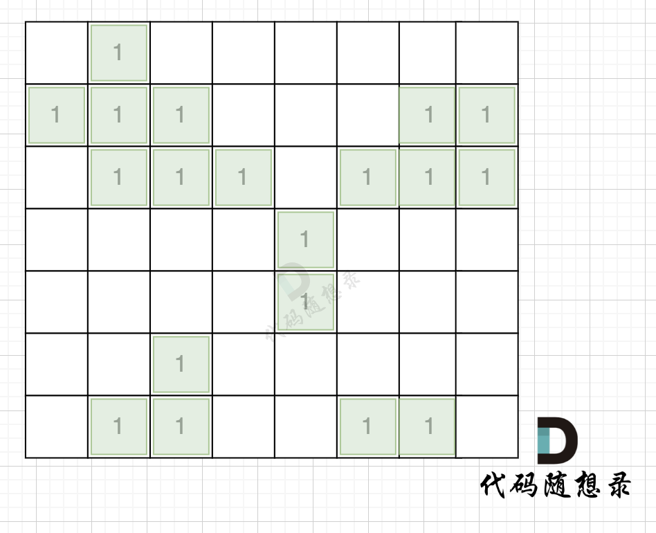
拿如下地图的岛屿情况来举例: (1为陆地)
第一步,则遍历题目,并将岛屿到编号和面积上的统计,过程如图所示:
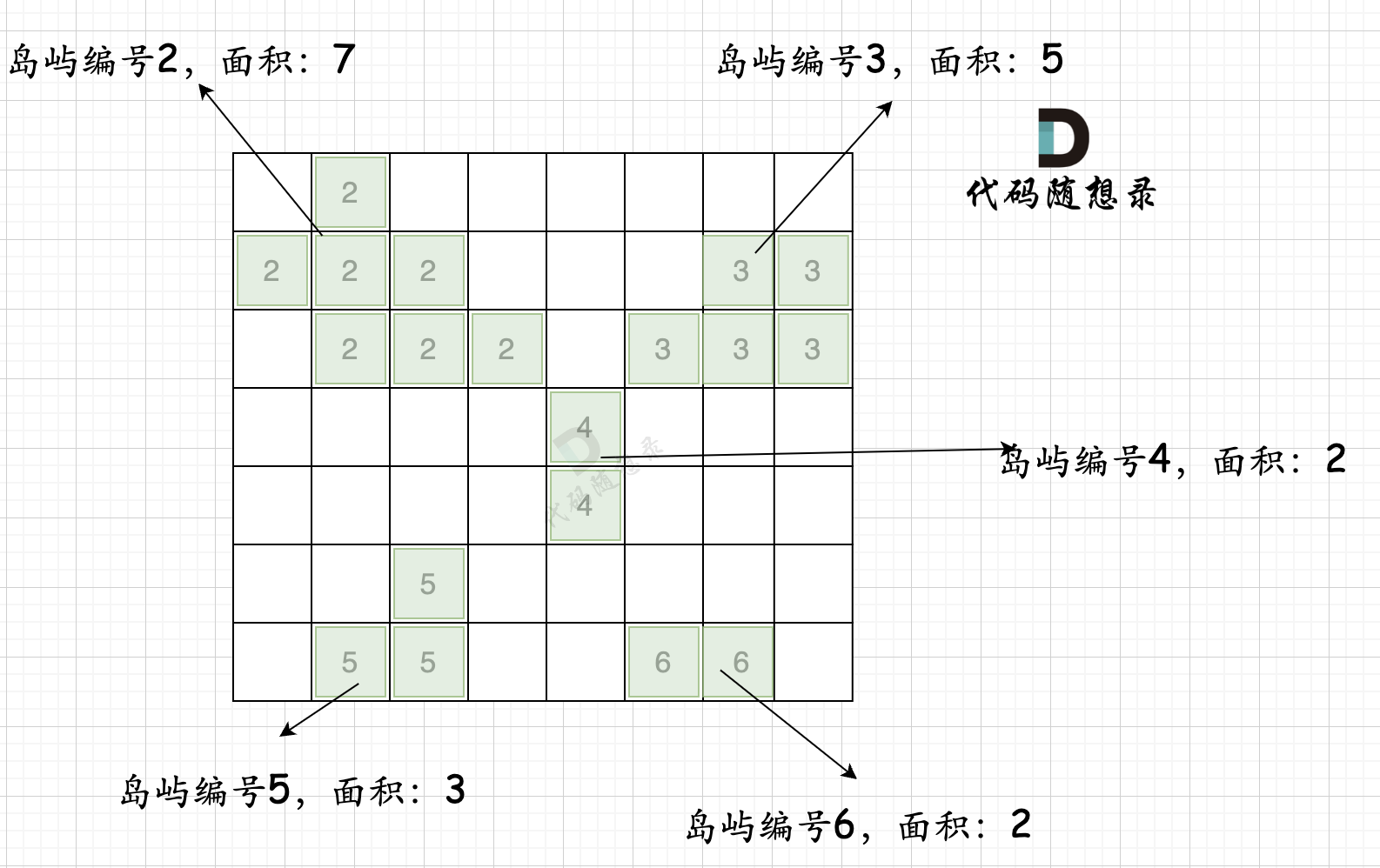
本过程代码如下:
int dir[4][2] = {0, 1, 1, 0, -1, 0, 0, -1}; // 四个方向 void dfs(vector<vector<int>>& grid, vector<vector<bool>>& visited, int x, int y, int mark) { if (visited[x][y] || grid[x][y] == 0) return; // 终止条件:访问过的节点 或者 遇到海水 visited[x][y] = true; // 标记访问过 grid[x][y] = mark; // 给陆地标记新标签 count++; for (int i = 0; i < 4; i++) { int nextx = x + dir[i][0]; int nexty = y + dir[i][1]; if (nextx < 0 || nextx >= grid.size() || nexty < 0 || nexty >= grid[0].size()) continue; // 越界了,直接跳过 dfs(grid, visited, nextx, nexty, mark); } } int largestIsland(vector<vector<int>>& grid) { int n = grid.size(), m = grid[0].size(); vector<vector<bool>> visited = vector<vector<bool>>(n, vector<bool>(m, false)); // 标记访问过的点 unordered_map<int ,int> gridNum; int mark = 2; // 记录每个岛屿的编号 bool isAllGrid = true; // 标记是否整个地图都是陆地 for (int i = 0; i < n; i++) { for (int j = 0; j < m; j++) { if (grid[i][j] == 0) isAllGrid = false; if (!visited[i][j] && grid[i][j] == 1) { count = 0; dfs(grid, visited, i, j, mark); // 将与其链接的陆地都标记上 true gridNum[mark] = count; // 记录每一个岛屿的面积 mark++; // 记录下一个岛屿编号 } } } }
这个过程时间复杂度 n * n 。可能有录友想:分明是两个for循环下面套这一个dfs,时间复杂度怎么回事 n * n呢?
其实大家可以仔细看一下代码,n * n这个方格地图中,每个节点我们就遍历一次,并不会重复遍历。
第二步过程如图所示:
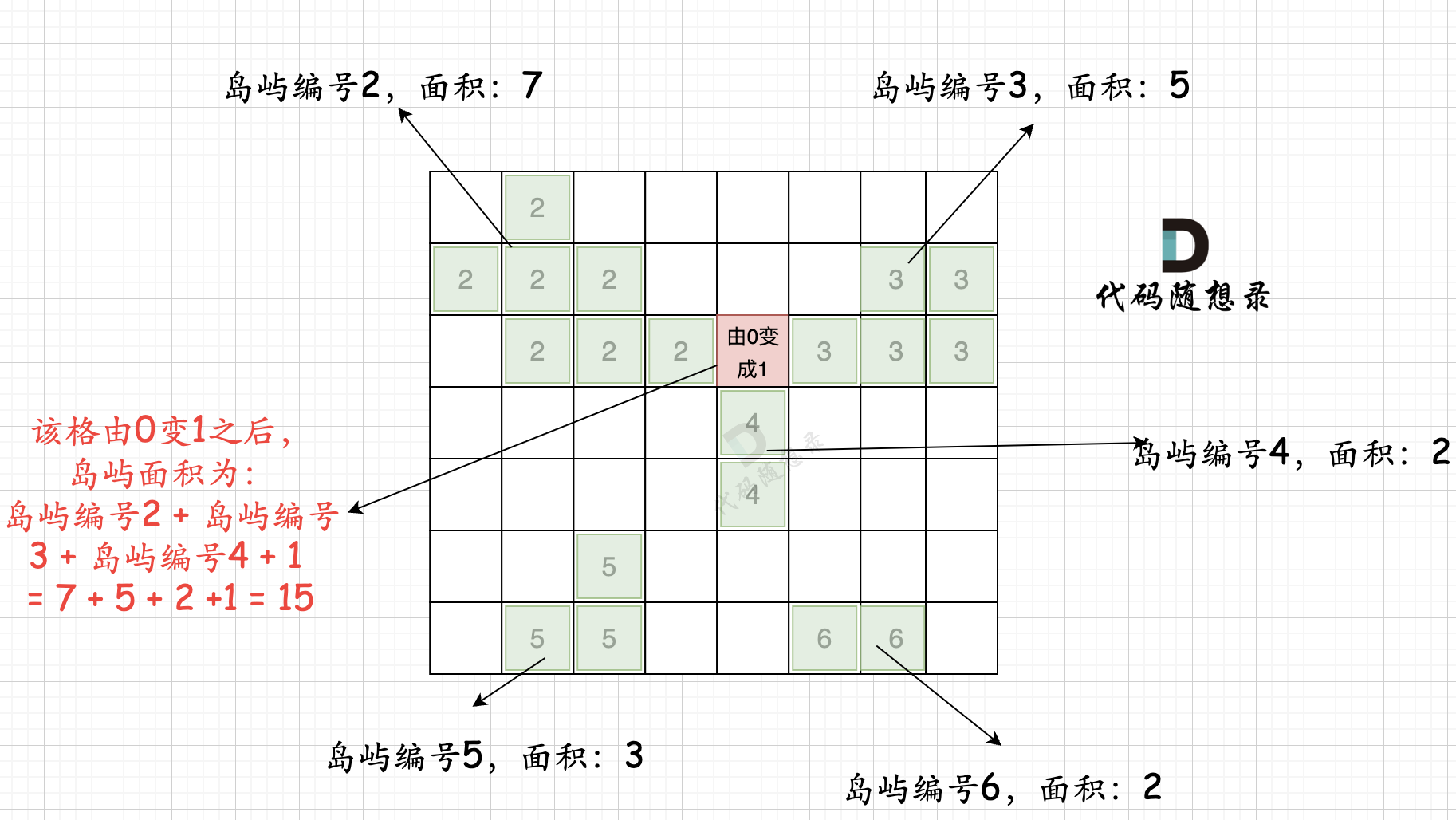
也就是遍历每一个0的方格,并统计其相邻岛屿面积,最后取一个最大值。
这个过程的时间复杂度也为 n * n。
所以整个解法的时间复杂度,为 n * n + n * n 也就是 n^2。
当然这里还有一个优化的点,就是 可以不用 visited数组,因为有mark来标记,所以遍历过的grid[i][j]是不等于1的。
代码如下:
int dir[4][2] = {0, 1, 1, 0, -1, 0, 0, -1}; // 四个方向 void dfs(vector<vector<int>>& grid, int x, int y, int mark) { if (grid[x][y] != 1 || grid[x][y] == 0) return; // 终止条件:访问过的节点 或者 遇到海水 grid[x][y] = mark; // 给陆地标记新标签 count++; for (int i = 0; i < 4; i++) { int nextx = x + dir[i][0]; int nexty = y + dir[i][1]; if (nextx < 0 || nextx >= grid.size() || nexty < 0 || nexty >= grid[0].size()) continue; // 越界了,直接跳过 dfs(grid, nextx, nexty, mark); } } public: int largestIsland(vector<vector<int>>& grid) { int n = grid.size(), m = grid[0].size(); unordered_map<int ,int> gridNum; int mark = 2; // 记录每个岛屿的编号 bool isAllGrid = true; // 标记是否整个地图都是陆地 for (int i = 0; i < n; i++) { for (int j = 0; j < m; j++) { if (grid[i][j] == 0) isAllGrid = false; if (grid[i][j] == 1) { count = 0; dfs(grid, i, j, mark); // 将与其链接的陆地都标记上 true gridNum[mark] = count; // 记录每一个岛屿的面积 mark++; // 记录下一个岛屿编号 } } } } }
不过为了让各个变量各司其事,代码清晰一些,完整代码还是使用visited数组来标记。
最后,整体代码如下:
class Solution { private: int count; int dir[4][2] = {0, 1, 1, 0, -1, 0, 0, -1}; // 四个方向 void dfs(vector<vector<int>>& grid, vector<vector<bool>>& visited, int x, int y, int mark) { if (visited[x][y] || grid[x][y] == 0) return; // 终止条件:访问过的节点 或者 遇到海水 visited[x][y] = true; // 标记访问过 grid[x][y] = mark; // 给陆地标记新标签 count++; for (int i = 0; i < 4; i++) { int nextx = x + dir[i][0]; int nexty = y + dir[i][1]; if (nextx < 0 || nextx >= grid.size() || nexty < 0 || nexty >= grid[0].size()) continue; // 越界了,直接跳过 dfs(grid, visited, nextx, nexty, mark); } } public: int largestIsland(vector<vector<int>>& grid) { int n = grid.size(), m = grid[0].size(); vector<vector<bool>> visited = vector<vector<bool>>(n, vector<bool>(m, false)); // 标记访问过的点 unordered_map<int ,int> gridNum; int mark = 2; // 记录每个岛屿的编号 bool isAllGrid = true; // 标记是否整个地图都是陆地 for (int i = 0; i < n; i++) { for (int j = 0; j < m; j++) { if (grid[i][j] == 0) isAllGrid = false; if (!visited[i][j] && grid[i][j] == 1) { count = 0; dfs(grid, visited, i, j, mark); // 将与其链接的陆地都标记上 true gridNum[mark] = count; // 记录每一个岛屿的面积 mark++; // 记录下一个岛屿编号 } } } if (isAllGrid) return n * m; // 如果都是陆地,返回全面积 // 以下逻辑是根据添加陆地的位置,计算周边岛屿面积之和 int result = 0; // 记录最后结果 unordered_set<int> visitedGrid; // 标记访问过的岛屿 for (int i = 0; i < n; i++) { for (int j = 0; j < m; j++) { int count = 1; // 记录连接之后的岛屿数量 visitedGrid.clear(); // 每次使用时,清空 if (grid[i][j] == 0) { for (int k = 0; k < 4; k++) { int neari = i + dir[k][1]; // 计算相邻坐标 int nearj = j + dir[k][0]; if (neari < 0 || neari >= grid.size() || nearj < 0 || nearj >= grid[0].size()) continue; if (visitedGrid.count(grid[neari][nearj])) continue; // 添加过的岛屿不要重复添加 // 把相邻四面的岛屿数量加起来 count += gridNum[grid[neari][nearj]]; visitedGrid.insert(grid[neari][nearj]); // 标记该岛屿已经添加过 } } result = max(result, count); } } return result; } };
其他语言版本
Java
class Solution { private static final int[][] position = {{-1, 0}, {0, 1}, {1, 0}, {0, -1}}; // 四个方向 /** * @param grid 矩阵数组 * @param row 当前遍历的节点的行号 * @param col 当前遍历的节点的列号 * @param mark 当前区域的标记 * @return 返回当前区域内 1 的数量 */ public int dfs(int[][] grid, int row, int col, int mark) { int ans = 0; grid[row][col] = mark; for (int[] current: position) { int curRow = row + current[0], curCol = col + current[1]; if (curRow < 0 || curRow >= grid.length || curCol < 0 || curCol >= grid.length) continue; // 越界 if (grid[curRow][curCol] == 1) ans += 1 + dfs(grid, curRow, curCol, mark); } return ans; } public int largestIsland(int[][] grid) { int ans = Integer.MIN_VALUE, size = grid.length, mark = 2; Map<Integer, Integer> getSize = new HashMap<>(); for (int row = 0; row < size; row++) { for (int col = 0; col < size; col++) { if (grid[row][col] == 1) { int areaSize = 1 + dfs(grid, row, col, mark); getSize.put(mark++, areaSize); } } } for (int row = 0; row < size; row++) { for (int col = 0; col < size; col++) { // 当前位置如果不是 0 那么直接跳过,因为我们只能把 0 变成 1 if (grid[row][col] != 0) continue; Set<Integer> hashSet = new HashSet<>(); // 防止同一个区域被重复计算 // 计算从当前位置开始获取的 1 的数量,初始化 1 是因为把当前位置的 0 转换成了 1 int curSize = 1; for (int[] current: position) { int curRow = row + current[0], curCol = col + current[1]; if (curRow < 0 || curRow >= grid.length || curCol < 0 || curCol >= grid.length) continue; int curMark = grid[curRow][curCol]; // 获取对应位置的标记 // 如果标记存在 hashSet 中说明该标记被记录过一次,如果不存在 getSize 中说明该标记是无效标记(此时 curMark = 0) if (hashSet.contains(curMark) || !getSize.containsKey(curMark)) continue; hashSet.add(curMark); curSize += getSize.get(curMark); } ans = Math.max(ans, curSize); } } // 当 ans == Integer.MIN_VALUE 说明矩阵数组中不存在 0,全都是有效区域,返回数组大小即可 return ans == Integer.MIN_VALUE ? size * size : ans; } }
Python
class Solution: def largestIsland(self, grid: List[List[int]]) -> int: visited = set() #标记访问过的位置 m, n = len(grid), len(grid[0]) res = 0 island_size = 0 #用于保存当前岛屿的尺寸 directions = [[0, 1], [0, -1], [1, 0], [-1, 0]] #四个方向 islands_size = defaultdict(int) #保存每个岛屿的尺寸 def dfs(island_num, r, c): visited.add((r, c)) grid[r][c] = island_num #访问过的位置标记为岛屿编号 nonlocal island_size island_size += 1 for i in range(4): nextR = r + directions[i][0] nextC = c + directions[i][1] if (nextR not in range(m) or #行坐标越界 nextC not in range(n) or #列坐标越界 (nextR, nextC) in visited): #坐标已访问 continue if grid[nextR][nextC] == 1: #遇到有效坐标,进入下一个层搜索 dfs(island_num, nextR, nextC) island_num = 2 #初始岛屿编号设为2, 因为grid里的数据有0和1, 所以从2开始编号 all_land = True #标记是否整个地图都是陆地 for r in range(m): for c in range(n): if grid[r][c] == 0: all_land = False #地图里不全是陆地 if (r, c) not in visited and grid[r][c] == 1: island_size = 0 #遍历每个位置前重置岛屿尺寸为0 dfs(island_num, r, c) islands_size[island_num] = island_size #保存当前岛屿尺寸 island_num += 1 #下一个岛屿编号加一 if all_land: return m * n #如果全是陆地, 返回地图面积 count = 0 #某个位置0变成1后当前岛屿尺寸 #因为后续计算岛屿面积要往四个方向遍历,但某2个或3个方向的位置可能同属于一个岛, #所以为避免重复累加,把已经访问过的岛屿编号加入到这个集合 visited_island = set() #保存访问过的岛屿 for r in range(m): for c in range(n): if grid[r][c] == 0: count = 1 #把由0转换为1的位置计算到面积里 visited_island.clear() #遍历每个位置前清空集合 for i in range(4): nearR = r + directions[i][0] nearC = c + directions[i][1] if nearR not in range(m) or nearC not in range(n): #周围位置越界 continue if grid[nearR][nearC] in visited_island: #岛屿已访问 continue count += islands_size[grid[nearR][nearC]] #累加连在一起的岛屿面积 visited_island.add(grid[nearR][nearC]) #标记当前岛屿已访问 res = max(res, count) return res
Go
func largestIsland(grid [][]int) int { dir := [][]int{{0, 1}, {1, 0}, {-1, 0}, {0, -1}} n := len(grid) m := len(grid[0]) area := 0 visited := make([][]bool, n) for i := 0; i < n; i++ { visited[i] = make([]bool, m) } gridNum := make(map[int]int, 0) // 记录每一个岛屿的面积 mark := 2 // 记录每个岛屿的编号 isAllGrid := true res := 0 // 标记是否整个地图都是陆地 var dfs func(grid [][]int, visited [][]bool, x, y, mark int) dfs = func(grid [][]int, visited [][]bool, x, y, mark int) { // 终止条件:访问过的节点 或者 遇到海水 if visited[x][y] || grid[x][y] == 0 { return } visited[x][y] = true // 标记访问过 grid[x][y] = mark // 给陆地标记新标签 area++ for i := 0; i < 4; i++ { nextX := x + dir[i][0] nextY := y + dir[i][1] if nextX < 0 || nextX >= len(grid) || nextY < 0 || nextY >= len(grid[0]) { continue } dfs(grid, visited, nextX, nextY, mark) } } for i := 0; i < n; i++ { for j := 0; j < m; j++ { if grid[i][j] == 0 { isAllGrid = false } if !visited[i][j] && grid[i][j] == 1 { area = 0 dfs(grid, visited, i, j, mark) // 将与其链接的陆地都标记上 true gridNum[mark] = area // 记录每一个岛屿的面积 mark++ // 更新下一个岛屿编号 } } } if isAllGrid { return n * m } // 根据添加陆地的位置,计算周边岛屿面积之和 visitedGrid := make(map[int]struct{}) // 标记访问过的岛屿 for i := 0; i < n; i++ { for j := 0; j < m; j++ { count := 1 // 记录连接之后的岛屿数量 visitedGrid = make(map[int]struct{}) // 每次使用时,清空 if grid[i][j] == 0 { for k := 0; k < 4; k++ { // 计算相邻坐标 nearI := i + dir[k][0] nearJ := j + dir[k][1] if nearI < 0 || nearI >= len(grid) || nearJ < 0 || nearJ >= len(grid[0]) { continue } // 添加过的岛屿不要重复添加 if _, ok := visitedGrid[grid[nearI][nearJ]]; ok { continue } // 把相邻四面的岛屿数量加起来 count += gridNum[grid[nearI][nearJ]] // 标记该岛屿已经添加过 visitedGrid[grid[nearI][nearJ]] = struct{}{} } } res = max827(res, count) } } return res } func max827(x, y int) int { if x > y { return x } return y }
JavaScript
var largestIsland = function(grid) { let res = 0; const m = grid.length; const n = grid[0].length; const tag = new Array(n).fill().map(_ => new Array(m).fill(0)); const area = new Map(); const dir = [[0,1],[0,-1],[1,0],[-1,0]]; const dfs = (grid,tag,x,y,mark) => { let res = 1; tag[x][y] = mark; for(let i = 0; i < dir.length; i++) { let nextX = x + dir[i][0]; let nextY = y + dir[i][1]; if(nextX < 0 || nextX >= m || nextY < 0 || nextY >= n) { continue; } if(grid[nextX][nextY] === 1 && tag[nextX][nextY] === 0) { res += dfs(grid,tag,nextX,nextY,mark); } } return res; } let mark = 2; //将岛屿用mark标记 for(let i = 0; i < m; i++) { for(let j = 0; j < n; j++) { if(grid[i][j] === 1 && tag[i][j] === 0) { area.set(mark,dfs(grid,tag,i,j,mark)); res = Math.max(res,area.get(mark)); mark++; } } } //将一个非岛屿格子变为岛屿 for(let i = 0; i < m; i++) { for(let j = 0; j < n; j++) { if(grid[i][j] === 0) { let z = 1; const connected = new Set(); for(let k = 0; k < dir.length; k++) { let nextX = i + dir[k][0]; let nextY = j + dir[k][1]; if(nextX < 0 || nextX >= m || nextY < 0 || nextY >= n || tag[nextX][nextY] === 0 || connected.has(tag[nextX][nextY])) { continue; } z += area.get(tag[nextX][nextY]); connected.add(tag[nextX][nextY]); } res = Math.max(res,z); } } } return res; };
